The digitization has helped to accurately survey our entire planet. Every mountain, valley, house, and road can be found on our maps.
There are no more blank spots on the map, right? Wrong! Humanity has surveyed everything above the water, i.e., over the oceans, lakes, and rivers. But how the landscape looks under the water is still largely unknown, even though the technologies required to survey underwater worlds already exist and there is a great interest in them.
Maps for scuba diving
Scuba diver Thomas Nemetz also knows this. In scuba diving, it is important to study the maps of the underwater landscape in which one wants to dive for preparation and safety reasons. However, in many cases, these maps do not exist. This is why many scuba divers hire a guide who knows the underwater terrain well. No maps required.
But Thomas Nemetz didn’t want to settle for that. This is why he founded the company Ocean Maps, which maps underwater worlds in popular diving spots like the Bahamas or the Florida Keys.
New markets for underwater maps
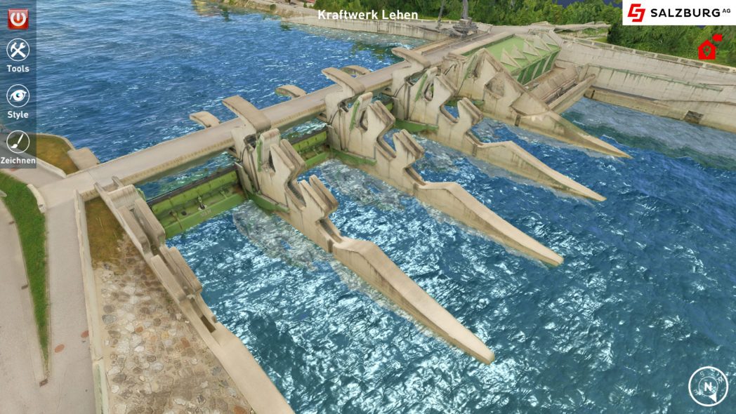
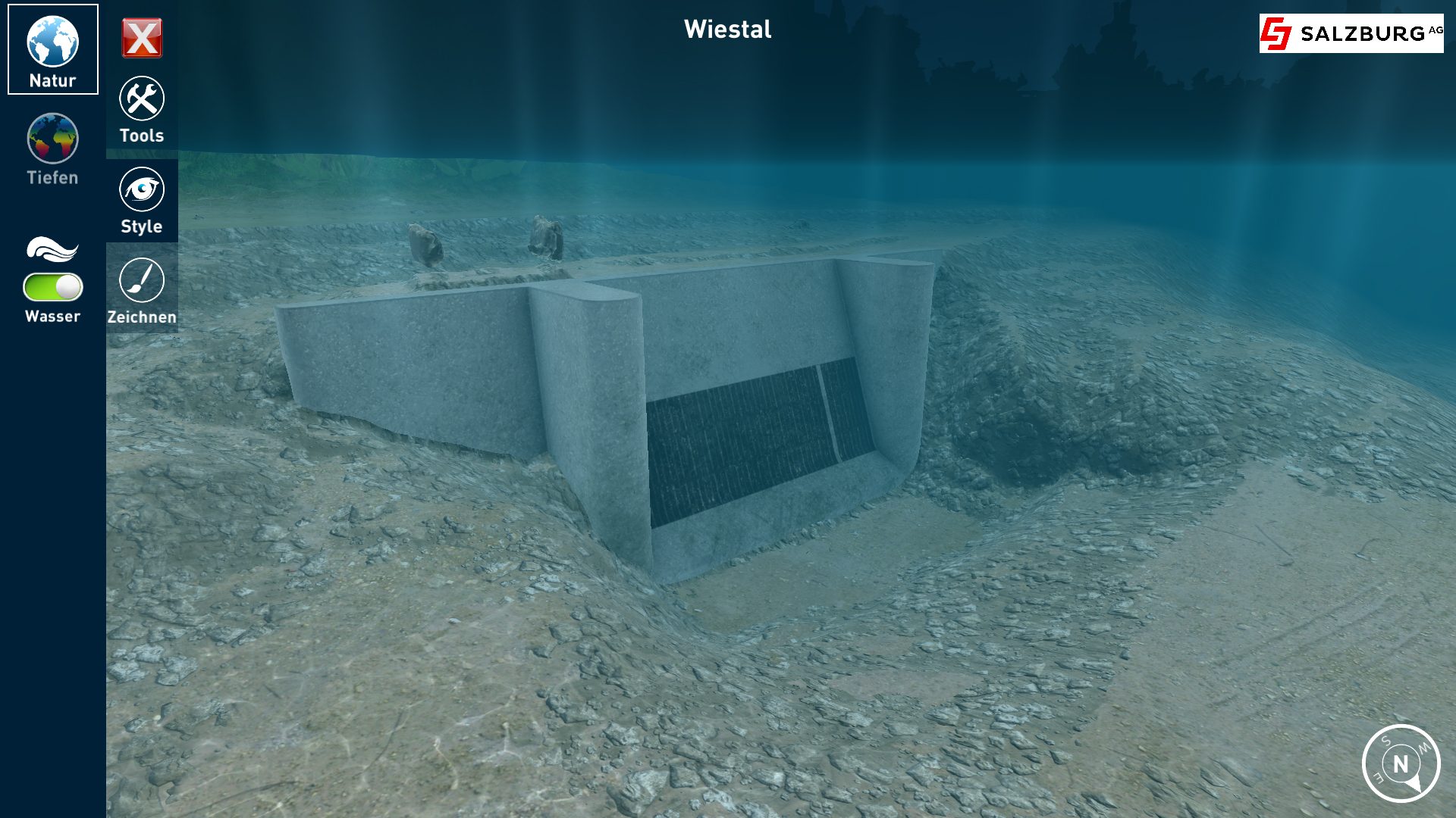
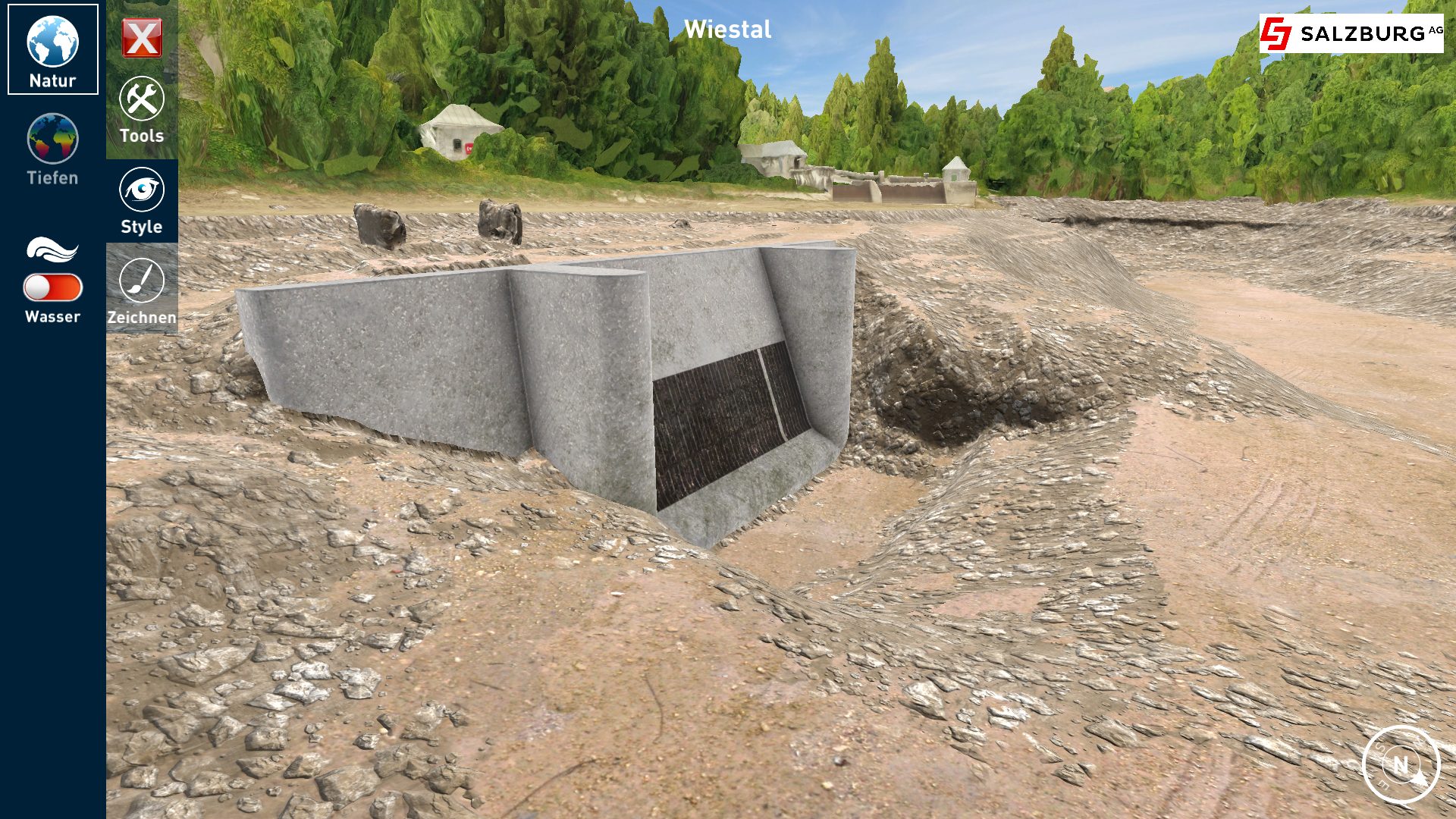
It quickly became apparent that other industries are also interested in underwater maps. As the scuba diving market experienced difficult times during the COVID-19 crisis, this was a welcome development. The demand from the energy and construction markets and the public sector is growing stronger and has long since overtaken that of the scuba diving industry. For operators of hydroelectric power plants, information on what it looks like underwater is essential. For example, they need to know if the turbine is running freely and where deposits are accumulating. Such information is also relevant for bridge construction or flood protection. “In the past, you could only get a picture of the situation underwater through divers. They were often impaired by poor visibility or swirling sand. A very expensive and time-consuming undertaking,” explains Thomas Nemetz.
Going into the depths with sound waves and diving robots
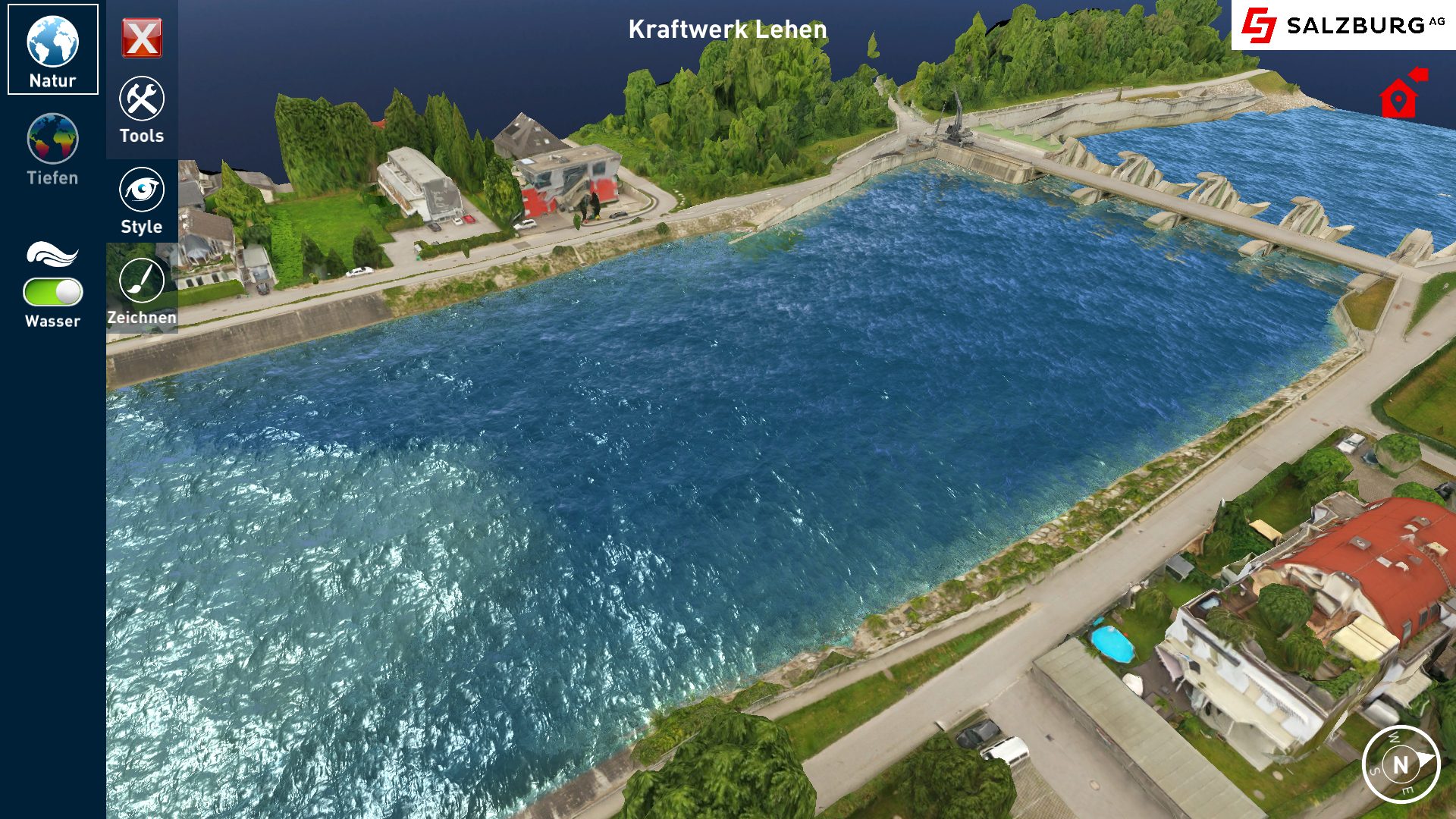
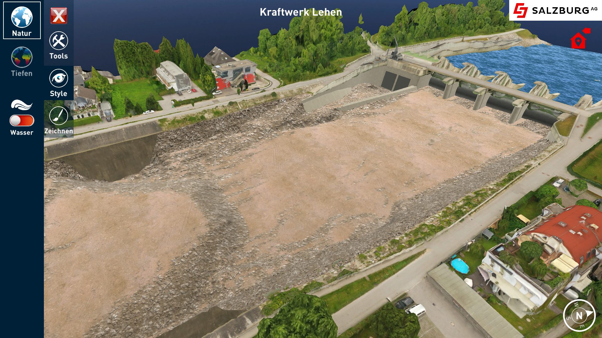
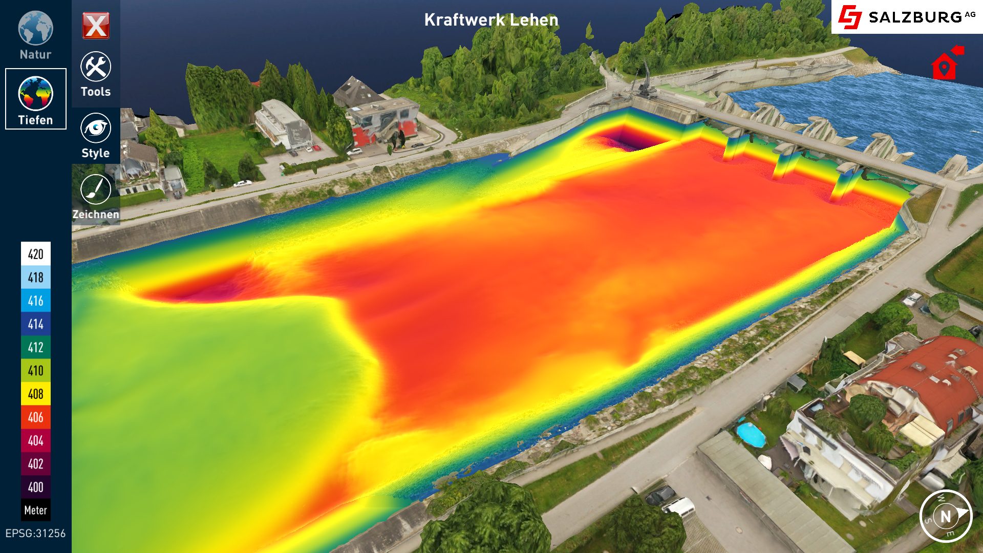
Ocean Maps uses state-of-the-art equipment for surveying. A multibeam sonar device is used to measure the depth of the water and the subsoil with sound waves. The speed with which the sound wave signal returns provides information about the depth of the water at a point, and the strength of the signal provides information about the subsoil. For example, if it returns very strongly, it is a concrete subsoil. There are only a few centimeters between the measurement points. From this, the Ocean Maps team can create a precise image of the underwater landscape in a very short time.
To generate further information about the underwater world, Ocean Maps also uses a diving robot. This remotely operated underwater vehicle (ROV) is easy to control and doesn’t stir up much sand. A camera on the ROV allows interesting objects, such as wrecks in scuba diving or larger obstacles at the turbine inlet of a hydroelectric power plant, to be viewed from multiple angles.
Measure, visualize, apply.
To draw a complete picture of the environment, Ocean Maps also uses images from sources such as drone footage, publicly accessible GIS data, or laser scans. All existing data is merged in a digital twin, a 3D model of the landscape above and below water. This makes it visible from a bird’s-eye view, underwater, or even indoors in a power plant or wreck. Users can thus get a detailed picture of the environment and use it for documentation, planning, or emergency purposes.
In the future, the digital twin is expected to be fed with even better data and equipped with artificial intelligence. The digitization of buildings (BIM – building information management) is increasingly in demand, and with its measurements and digital twin, Ocean Maps is helping to digitize existing structures such as power plants and bridges. This could enable an AI to predict when a bridge needs to be renovated in the future. Ocean Maps sees its digital twin software as its major market for the future, as it is highly scalable. “I can use it to map a thousand bridges and facilities.”
Staying innovative with R&D, funding, and patents
To remain innovative, Ocean Maps regularly participates in research projects, such as with the Department of Geoinformatics at the University of Salzburg. The company already holds seven patents, particularly in the software area. To support research projects and patent applications, Thomas Nemetz frequently relies on funding. “Rolling out patents internationally is expensive, but it is particularly important in the software area.” The company seeks support from our funding and intellectual property law advice when applying. “Innovation Salzburg is my first port of call when it comes to funding.”

This might also interest you
28. May 2026
Joint Research Leads to Patent Application
An important milestone for Salzburg as a research and innovation hub: Salzburg University of Applied Sciences and ABB’s Machine Automation Division (B&R) have jointly filed a patent application in the field of AI-based energy efficiency.
21. May 2026
The Future of Microchip Manufacturing Comes to Salzburg
With the opening of a new competence center for so-called panel-level packaging, Lam Research is sending a strong signal for Salzburg as a technology and research hub.
15. April 2026
From AI to energy: Four Salzburg companies recognised
In 2026, the Salzburg Innovation Award was presented for the first time, introducing a new distinction for particularly innovative companies in the region. The four awarded projects highlight the diversity of innovation in Salzburg – ranging from satellite data and artificial intelligence to recycling technologies and digital energy infrastructure.
12. March 2026
SALZ 2026: Innovation and Technology in Focus – Startups, AI and Future Markets in Salzburg
The SALZ – Festival for Innovation & Technology brought together companies, startups, research institutions and public stakeholders at Messe Salzburg on 11 March 2026. With keynotes, panels, matchmaking and startup pitches, the event provided a platform for emerging technology trends, new collaborations and exchange within the innovation ecosystem.